
Alignment Management

Alignment Management offers functions to copy, delete, rename and transform alignments. The alignments are managed together with their properties and design guidelines.
When exchanging data with third party systems, the alignment master points can be imported and exported using the applicable card types.
Alignment Evaluation
You can use this module to analyse and evaluate calculated and saved alignments using various methods.
The results are displayed immediately and also printed if desired. Any calculated coordinates can be saved to the card_1 point database.
Automatic Alignment
You can automatically generate alignments from existing points from the card_1 point database. You only require a sorted set of points to generate alignments automatically.
The points can originate from check surveys or may be digitized on-screen using orthophotos or scanned maps. Previously existing and calculated alignments can be reproduced easily and quickly.
Swept Turning Path
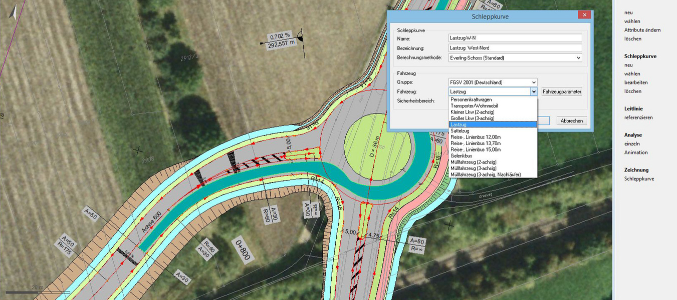
Calculate swept turning paths based on the vehicle track method, incl. vehicle library. Display in the base map, simulation of the manoeuvres, various evaluation functions.
Alignment Design
You can design road alignments for built-up and rural roads on-screen together with roundabouts and at-grade (single level) junctions taking the applicable design guidelines into account.
Scanned maps, orthophotos, digital data, check surveys and DTMs are the data basis for the alignment design. Especially when planning roads, the advantages of the card_1 system's properties make themselves apparent.
Vertical Alignment Transformation
You can use this module to calculate dependent vertical alignments for ramp alignments, or transform vertical alignments onto other more or less parallel alignments.
Cross-fall Generator

You can use this module to automatically generate cross-fall strings which conform to the relevant design guidelines and which are optimized in terms of vehicle dynamics. The road surface type, the vehicle dynamics parameters as well as the spatial route geometry are taken into account. The program supports any designs that conform to the relevant guidelines, roads with empirical parameters and inner-city streets with constrainments according to the German guidelines of the FGSV. The speeds are also taken into account. An interactive v85 speed generator is integrated in the program.
When dealing with routes which do not comply with the relevant design guidelines (especially existing routes), twist-related corrections may be defined to ensure controllable steering; the parameters required are simulated thus substantially increasing safety and driving comfort.
Cross-Section Design / 3D Route Structures / Cross-Section Design (Rail)
Automatic development of cross-sections, surface elevation list. Basic system of smart infra-modelling technology for parameterised, rule-compliant and technical development of 3D route structures for roads, motorways, footpaths and cycle paths; generation of roadways without junctions and intersections; simple design of roadsides. Requires the Cross-Section Editing module.
Cross-Section Transformation
This module enables you to transform and move cross-sections. The cross-section lines are transformed so that they retain their original approximate plan position.
Moving cross-section lines is useful if the chainages of the alignment originally used have had to be modified during the design process. The use of this function eliminates the need to create new cross-sections at the modified chainages. This is especially useful if the cross-sections cannot be generated again, either because they were created manually or have been extensively revised. more >
Volumes from Cross-Sections
You can calculate volumes and surfaces from cross-sections according to the guidelines REB-VB 21.003 and REB-VB 21.013. Any data and parameters used to control a volume calculation are saved, thus enabling the calculation to be entirely checked and analysed at any time.
Cross-Sections from Points
This module enables you to calculate cross section lines and longitudinal profile lines according to the guidelines REB-VB 20.003 from existing cross-sections and longitudinal profiles which have been surveyed as topographic points. more >
Cross-Sections from Lines
You can calculate alignment related cross-sections and longitudinal profiles from lines of the card_1 base map. This method is very convenient if the base map data provides sufficient information or the creation of a digital terrain model is not required or not possible; e.g. digitized contour lines. more >
Surface Optimization
This module enables you to optimize existing road surfaces and makes reconstructing existing traffic routes very easy.
The main field of application for this module is to calculate vertical alignments and to analyze vertical alignments for 'overlay' resurfacing of roads of any category. Based on a new genetic algorithm, the program automatically picks the optimum vertical alignment from a range of variations.
Alignment Drawing / Alignment Drawing (Rail)

You can create complete and technically sound alignment drawings with flexible annotations, carriageway edges and gradient changes. The batch mode enables you to generate multiple drawings in one step.
Alignment drawings may be displayed as a background layer in all base maporiented applications.
Profile Drawing (Sewer)
You can create complete, technically-sound profile drawings in compliance with the existing guidelines with flexible annotations, sewers and other strings.
Sewer profile drawings may also be generated in reference to any existing road longitudinal profile. These drawing portions are displayed in the same manner with tangent strings, dimensions, drawing sheet borders and titleblocks in one drawing.
Cross-Section Editor
This module enables you to perform your cross-sectional design and calculation tasks. All editing is done in the graphics, starting with the design of cross-sections right through to the determination of volumes. Any existing width strings, cross-fall strings and vertical alignments can be used as planning aids.
If required, you can obtain a 3D effect by taking the neighbouring chainages into account when deciding on design issues.
You can also interactively calculate the cross-section volumes and you can output these volumes together with the individual values. more >
Cross-Section Drawing / Cross-Section Drawing (Rail)

You can create cross-section drawings with individual sheet positioning, flexible annotation and design.
You can display and output surveying vehicles, road and rail furniture objects, trees and hedges. more >
Route Simulation
Animated test-drive of roads and railway tracks plus fly-overs in the 3D project model. To test project data visually or for presentations. Visualize the sight distances according to RAL, HViSt and others.
This Module supports the BIM-planing process.
Regulations Catalogue
Creation, output and management of regulation catalogues (RV) according to the German guidelines RE 2012, including automatic number updates in forms and drawings as well as drawing generation and adaptation.
Bridge Generator
Generate bridges as structures as part of the route development. BIM-standard structure of the assemblies. Use for drawings, sight distance calculation, structure catalog and BIM export. Standard bridge schematics included.
OKSTRA Export Design
Export card_1 data (schematics: 008 – design, 018 – geometry, 021 – general. Geometry objects incl. point clouds, 022 – land acquisition (requires Land Acquisiton Logging module), 024 – Cadastre, 030 – topography) in the OKSTRA format.
OKSTRA Import Design
Import data (schematics: 008 – design, 018 – geometry, 021 – general. Geometry objects incl. point clouds, 030 – topography) in the OKSTRA format.
VESTRA Import Route Data
Import route data in the VESTRA format (S40) as card_1 alignments incl. description.
Sight Distances

With one mouse click, you can determine the required as well as the actual stopping and overtaking sight distances; for both directions of travel and according to the relevant guidelines. You can calculate the actual sight distances by choosing either a vertical alignment-related 2D method or a complex 3D method which takes the three dimensional geometry of the road into account.
The information on the determined sight distances is displayed in a very clear manner in the graphics and can be integrated into longitudinal profile drawings, cross-section drawings and into base maps. The required sight distances can easily be determined using the card_1 route simulation.
This module supports the BIM planning process more >
card_1 makes it easy to check that your designs are in line with the Visualisation Guidelines HViSt for standard spatial elements, concealed starts of curves and critical areas of obstructed vision.
Point Management DB AG
AVANI-compliant preparation of geometric and topological data to verify and process German Federal Railways track data. Automatic generation of German Federal Railways numbering districts (drawing areas, incl. sheet lines) and key directories. Numbering-district-based management of the main points for German Federal Railways tracks. Numbering and attribution according to AVANI specifications.
Vertical Alignment Design / Vertical Alignment Design (Rail)
Designing and editing vertical alignments is similar to designing alignments, in that you can conveniently design and edit them on-screen taking constraining points into account. The relevant design data is displayed and synchronized in the various views, e.g. longitudinal profile, curvature string and cross-fall string.
In the card_1 system, vertical alignments are height profiles defined using tangent intersection points. They are used not only to describe the vertical profile of roads, railways and sewers, but also as height definitions for swales, ditches, carriageway edges and other alignment-related structures. Individual evaluations or evaluations as lists are integrated in the application.
3D Road Design
Parameterised, rule-compliant and technical 3D design of roads including their various intersections; consideration of secondary conditions such as water protection areas; automated markings and signage. Requires the Cross-Section Design/3D Route Structures module. The 3D Design Elements module is also recommended.
3D Design Elements
Interactive, parameterised and technical design of roadsides, squares, driveways and traffic areas; equipment with 3D symbols, railings, trees and general as well as individual equipment from catalog cross-sections.