
General
All of the base modules which form the foundation for one-stop project work are subsumed under the term System.
System
All card_1 modules are based on the basic module System. The modern MDI technology, a clearly structured data presentation and the technically sound design of the user interface are features of the basic module.
An easy-to-use project manager and file manager, a text editor, table editing, catalogues, technical presettings, project samples, system services and a comprehensive online documentation are fully integrated in the system. The basic module is free of charge.
CardScript
Develop and execute scripts with the integrated card_1 programming language CardScript. Automate processes. Easy data handling: generating, altering, evaluating and analyzing project data. Results exported in files, graphics and reports. Data exchange via CSV, XML, Excel and SQL. Documentation and example scripts come with the software.
Drawing Editing
You can create, edit and compile scale-related or project-related drawings with this module. The drawings can be output to any common plotters or printers.
Clear drawing structures, convenient editing functions and a sound management system aid you when creating drawings. The structure and architecture of the drawings as well as the various features to re-use drawing components helps you to avoid doubling up on work and to quickly create follow-up drawings.
The multi-user feature is ideal for planning teams. Within one project a project group can work on the different components of a drawing simultaneously.
Drawing Editing is required to manage and output drawings which you previously generated with the drawing generators in the areas base map, alignment, vertical alignment, cross-section, rail and sewer.
Hybrid Drawing Editing
You can jointly output raster data and vector data into one drawing with this module, i.e. you can mix raster data and vector data in one drawing.
This is a very easy way to upgrade your drawings by simply adding your clients’ logo or trademarks. Or you can incorporate photos for project documentation purposes or overview maps.
Virtual Reality
Displaying 3D project data in virtual space. Move freely within the 3D project. Simulate routes and assess sight distances in virtual space. Detect conflicts/glitches more easily. Real simulaton. Clear presentations and visualisation.
Image Documentation
Photo and video documentation for projects. Importing and managing geo-referenced images. Automatic transformation and positioning of images containing coordinates. Display and editing of images in the base map.
3D Project View
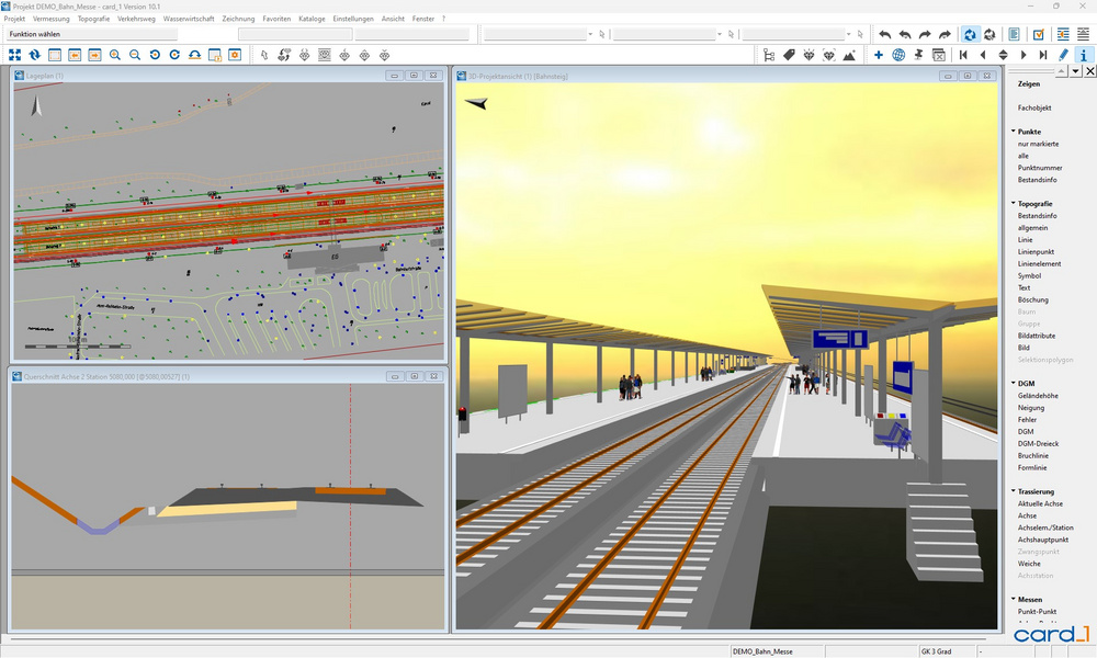
The 3D Project View enables you to analyse your project data in 3D and helps you to locate possible glitches or errors in your design at a very early stage.
The software has been highly optimized in order to process even large quantities of data quickly and conveniently. E.g. complex digital terrain models and point clouds which as a 3D image can display any detail from any angle, thus ideally complementing the information on the existing conditions.
This module supports the BIM planning process.
Modelling Existing Conditions
Generating 3D objects of the existing conditions incl. user defined or code based attribute assignment.
Issue Management
Creating and managing reports (issues) in card_1 projects. Import/export via BCF and synchronization of issues as part of BIM collaboration. Visualisation of viewpoints in the base map view and in the 3D project view. Recording and managing report status, user, priority, due date, description and comments for issues.
Visualisation
Photorealistic representation of traffic signs, street furniture and vegetation as a 3D model in a card_1 catalog/rules framework. Import function to incorporate your own 3D symbols. The 3D symbols are also used by the new design systems to visualise technical objects. For visualisation in the 3D Project View, Route Simulation and Virtual Reality. Requires the 3D Project View module.