
Topography
You can use the card_1 topography modules for the following tasks: topographic data logging, planning, creation of engineering-standard base maps, miscellaneous evaluations and topographic data exchange.
The topography modules provide excellent project data editing and evaluation features. You can structure your data within up to 32,000 layers. The amount of data is limited by the operating system and the disk space only.
There is no need to define map scales, map sheets or drawing guidelines beforehand. Comprehensive symbol and line style libraries are part of the installation package and enable you to start with your project work immediately.
Base Map
More than 300 functions are at hand when working on topographic data. You can use these functions to design on-screen, to edit and manage points, lines, texts, symbols and other data in the base map.
There are several available to generate engineering-standard slope hachures. Numerous evaluation functions, e.g. to generate annotations or to calculate areas, support you when pre-processing the project, when checking the project data or when creating the results reports.
When working on a project there is no need to define any map sheets, map scales or drawing guidelines. The size and position of the sheets as well as the relevant drawing guidelines are defined at the very end when producing the drawings. This avoids any redundancy in your work which would otherwise be inevitable in planning systems based on sheet-oriented data management.
Base Map Generator

You can use this module to create your base map data more easily by automatically creating this data from survey points. You can log the data of traffic routes, buildings, slopes, ditches, utilities or sewer networks and structure the data in layers.
The generator eliminates tedious and repetitive manual work and enables you to automatically run multiple editing steps in one go based on your settings. Thus significantly reducing the number of errors and the time normally spent on these tasks. It makes the project work much quicker and easier as well as more economical. more >
Base Map from Cross-Sections
You can import the relevant cross-sectional information, e.g. points, lines and slopes into the base map.
Raster Image Display
You can combine your project data with convincing raster data in order to clearly present your designs to your clients, with for example: scanned-in drawings, maps, aerial photos, satellite photos or other types of raster data.
Raster images can be displayed in all base-map-related modules, such as Base Map or in Alignment Design.
Raster Image Editing
In many cases there is no need to laboriously digitize existing plans and aerial photos but just use them as-is as a planning basis. This module offers powerful editing and export features for such data.
By integrating maps, satellite photos and other images into your project data you can significantly increase the level of project information; thus presenting your planning tasks more precisely and clearly.
Raster Image Digitizing
You can digitize points and lines on-screen, based on scanned-in maps. This module is an indispensable add-on when manually compiling data at the digitizing board - especially when dealing with large amounts of data.
Thanks to the numerous convenient on-screen editing functions and the excellent display features you can achieve an evenly high quality of the digitized data.
Digital Terrain Model
You can create and edit digital terrain models with this module. DTMs are the basis for volume calculations and surface-related studies, e.g. road drainage systems for intersection points. You can also derive longitudinal profiles, cross-sections and contour lines from digital terrain models.
Digital terrain models are one of the many data bases for the 3D Project View in card_1.
DTM Volumes
This module enables you to calculate the volumes in relation to a user-definable horizon or the volumes between two digital models with an identical hull according to the German guidelines REB-VB 22.013. This method is especially suitable for calculating the volumes of extraction sites, quarries, gravel pits, landfills, dams, reservoirs and for designing traffic routes.
You can chose this method when dealing with digital terrain models which either have identical hulls or share the same plan area.
DTM Intersection
This module enables you to calculate the volumes between two digital terrain models by intersecting them according to the German guidelines GAEB-VB 22.114. This method is especially suitable for purely cut and fill projects, e.g. foundation ditches, dams, landfills, but also for cut and fill projects such as airfield constructions, industrial areas and landscaping.
You can chose this method when dealing with digital terrain models which have neither identical hulls nor do they share the same plan area.
SoundPLAN Export
Export topographic and planning data to the program SoundPLAN.
OpenStreetMap Import
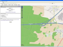
Import data in the OpenStreetMap-format as card_1 topographic data.
GEOgraf Import
Import data in the GEOgraf format as base map data.