Been on your bike today?
Could rapid bike paths be the transit ways of the future? Klinger und Partner GmbH of Stuttgart (KuP) show how unused thoroughfares can be converted and re-deployed in a more contemporary fashion. Covering a wide area with rapid transit bike paths is one way to link key locations over large distances. Such paths would have to be safe, attractive and designed for high-speeds.

In Schorndorf, near Stuttgart, the "new B10 carriageway in Filstal" project was presented by KuP at the card_1 infoDay on 22 June 2017.
Initial Position
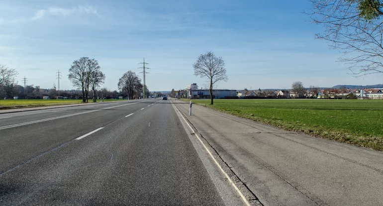
Once the new B10 bypass is finished the towns and communities in the Filstal valley should experience a significant drop in through traffic. When the Gingen bypass, the final stage of construction, is opened, an expected 5,000 vehicles a day will still use the existing road between the towns of Eislingen and Süßen. The old three to four-lane road between Eislingen, Salach and Süßen can then be reduced to a one-lane cross-section with accompanying pedestrian and bike paths.
This partial reduction of the former B10 had already been planned for in the 1990s and was an integral part of the environmental balance concept.
Green Politics

Over the last few years Baden-Württemberg's priorities have changed dramatically in terms of traffic policy. The Green-led state government has made paving the way for sustainable and modern mobility a priority and is looking to raise the share of bikes on the road from about 8% today to 20% by 2030. The RadKULTUR Initiative founded in 2012 aims to motivate commuters to incorporate bikes more into their everyday lives; aided by a growing interest in e-bikes and pedelecs (source: www.radkultur-bw.de).
Good Bike Paths
In order to achieve this goal, the project must create a wide-ranging, integrated network of paths which both connect the main settlements and are suitable for everyday use. This so-called RadNETZ (bike network) is to be approx. 7,000km long and will look after the needs of everyday bike users (source: radnetz-bw.de).
Project Start
Although the sections of road affected by the B10 project already have bike paths between settlements, they are largely unacceptable in terms of quality standards : outside the towns they frequently cut through fields far from the road and within built-up areas follow side streets, often without any special bike path markings. The plans to scale down the old B10 meant that an attractive and acceptable bike path network could run alongside the former highway. So naturally the original plans were checked to see if they could incorporate the new requirements.
Feasibility Study
The communities of Eislingen, Salach and Süßen hired KuP in 2017 to conduct a feasibility study, the aim being to identify possible potentials and conflict points for the subsequent design of fast and safe bike paths. card_1 users had to check whether elements of a rapid transit bike path could be incorporated into the plans. These included elements such as higher average speeds and shorter waiting times at junctions - yet more advantages of switching to the bicycle.
Cost-effective Bike Paths
As expected, the sections out of town were ideally suited to a rapid transit bike path. The cross-section measurements of the decommissioned lanes were sufficient to accommodate the 4m-wide bike path plus the road markings dividing the car and bike lanes. No additional land purchase was needed. The environmental inspections did however need reviewing, as keeping the old carriageway resulted in a greater area of sealed road than removing it would have. Given that part of the road surface will continue to be used, the bike paths can be inexpensively achieved. There is little difference in elevation along the route thus allowing high speeds.

Variations in Built-Up Areas
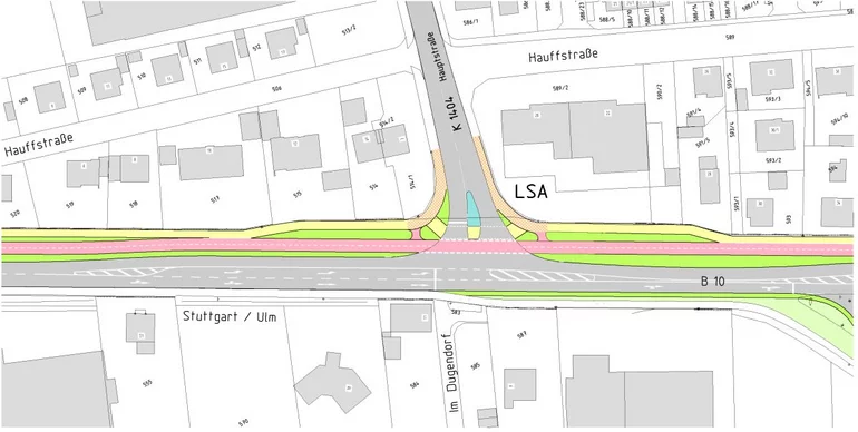
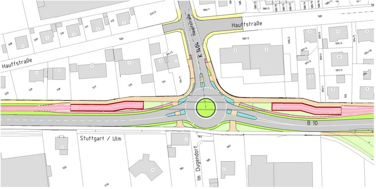
Many junctions within the built-up areas punctuate the former B10. Surveys have shown that although solutions acceptable to ERA rules are possible, the at-grade junctions as planned would add to journey times. In addition, costly and elaborate grade separated over/underpasses will have to be built in order to fulfil the specifications of a rapid transit bike path. The short distances between junctions coupled with the long ramps required by these passes make it virtually impossible to comply with the parameters.
Result
On the basis of a feasibility study, KuP's engineers have proved that in non built-up areas a high standard of both normal and rapid transit bike paths can be provided at relatively little cost. Within built-up areas, however, each individual over/underpass must be weighed up as to whether the possible gains in journey time justifies the additional expense, as opposed to traffic lights.
Varying Consequences
The project, once concrete, showed that involving several communities resulted in quite different political priorities. Whereas one settlement placed great emphasis on improving bicycle mobility, in another, bikes should give way to the needs of motorised vehicles. All in all, the results favoured shifting the design of rapid transit bike paths to district, regional and state levels.
Johannes Kuhn, infrastructure expert and KuP's branch office manager in Urbach commented: "The state government's RadSTRATEGIE definitely offers us planners new and exciting aspects. We look forward to interesting discussions and the first of such 'modern mobility' projects completed in the automobile state of Baden-Württemberg".
card_1 in Operation
Kuhn further remarked: "We've been working with the card_1 program package for many years. We've come to rely heavily on the two modules Route Simulation and Building Structures Generator: indispensable for checking the routes we're designing visually."
When planning the demolition/conversion of the roads into a rapid transit bike path network, the focus was on the detailed cross-section development and DTM. This was in order to replicate the line of the road exactly in areas of barely sloping ground, to check drainage issues, for instance.
Planning Culture
With the help of project examples, KuP also used the infoDay to expound on a new planning culture. They began by presenting the historical development of planning methods, starting with 2D base maps, elevation plans and cross-sections, and went on to look at the future of designing in 3D and its advantages. At town-hall discussions in particular, projects should be clearly presented and easily interpreted using modern, innovative 3D displays, including images, sound and video. And it won't be long before KuP is using VR headsets to give their clients virtual project tours - possible thanks to the new card_1 VR module.
And by the way: KuP's presentation is available to be viewed in card_1's Support Center - well worth a look!
Contractor:
Klinger und Partner
Ingenieurbüro für Bauwesen und Umwelttechnik GmbH
Niederlassung Urbach
Neumühleweg 43
73660 Urbach
Fon +49 7181 99946-0
Fax +49 7181 99946-21
Friolzheimer Straße 3
70499 Stuttgart
Fon +49 711 693308-0
Fax +49 711 693308-99
www.klinger-partner.de und www.uw.eu